This was a combination trip – explore a Forest Road that has been on our to-do list (FR 10) and take advantage of the Forest Service’s permission to cut a Christmas tree. We first stopped by the Forest Service Ranger Station in Jemez Springs for our tree-cutting permit. For $10, we could go anywhere in the National Forest and cut any species of tree; we were given a map and suggestions on places to go. Since we had FR 10 on our minds, we chose to proceed on up NM 4, then start at the north end of FR 10 and exit at the south end, passing familiar places: Goblin Colony, Kiatsukwa and Boletsakwa ruins, and Paliza Campground on our way out.
The Drive In
FR 10 begins at NM 4, about 7 miles east of La Cueva, where one drives through the neighborhood of Vallecitos de los Indios. We travelled about 2.5 miles, including a stretch of road that is on the side of the mesa, thus a bit narrow with a steep falloff on the right. Once atop the mesa, we spontaneously decided to leave FR 10, turning right onto FR 136. This road was a two-track, but obviously heavily used. We drove along FR 136 for about 2.5 miles, where it began to get twisty and steep.
The Hike
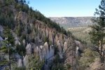
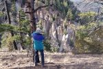
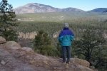
We parked and began hiking down the road with a couple of diversions toward the edge of the mesa for the impressive views down into the East Fork of the Jemez River. (We thought we were looking down upon Jemez Falls, which we visited recently. At home, looking at Google Earth, we were some distance downstream from the Falls; the view was spectacular none the less.) The second diversion led us to an area ideal for camping; with road access and opens pace, it is on our list for future overnight trips. And, from this vantage point, we looked down upon an amazing array of hoodoos; check out the photos below. 
Another purpose for our diversions was to find a Christmas tree. There were many good looking trees from which to choose – we found one to our liking, cut it with the bow saw we had brought, and put it in the truck to take home. After a snack break, we headed back to FR 10 and south towards home.
Statistics
Total Distance: 2.35 miles
Elevation: start 8,417 ft, maximum 8,493 ft, minimum 8,206 ft
Gross gain: 287 ft. Aggregate ups & downs: ascending 665 ft, descending 666 ft
Maximum slope: 48% ascending, 51% descending, 10% average
Duration: 1:49
| GPS Track Files for Download | |
79 Downloads |
|
|---|---|
27 Downloads |
|
75 Downloads |
|
32 Downloads |
|
I urge you to explore our hiking tracks with Google Earth. With the virtual 3-dimensional presentation, achieved by panning and tilting the view, you can get a much better idea of the hikes and terrain than you can get from the 2-dimensional screenshot above. For assistance: Using Google Earth Track Files.


