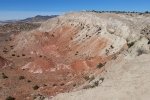
A beautiful spring day in the Land of Enchantment: 70 degrees, light breeze, lots of sunshine. Great day for Pat and me to head out for a hike, to the nearby White Mesa Bike Trails.
The Hike

White Mess Bike Trails.Pat.2017-03-09. US 550 is beyond the far end of Dragon’s Back, and the Nacimiento Mountains are on the horizon, upper right.
We hiked the less precipitous trails, not the Dragon’s Back trail that Vince and I did back in 2016. The views are stunning, 360 degrees around the horizon, from Sandia Mountains to the east, Sangre de Cristo just above the Jemez Mountains to the northeast, the Nacimiento to the north, the Ojito Wilderness to the west, and Mount Taylor above Mesa Prieta to the southwest. And the view into the “badlands” that form the center if the Bike Trails is amazing.
Statistics
Total Distance: 2.32 miles
Elevation: 5,831 start, 6,040 maximum, 5,831 minimum
Gross gain: 211 ft. Aggregate ascending 338 ft, descending: 336 ft
Maximum slope: 16% ascending, 23% descending, 5% average
Duration:
| GPS Track Files for Download | |
87 Downloads |
|
|---|---|
29 Downloads |
|


